Chapter 4 - NEW LANDS
The Home of
the Blizzard By Douglas Mawson
Preface
Chapters:
1 - The Problem
and Preparations |
2 - The Last
Days of Hobart and the Voyage to Macquarie Island |
3 - From Macquarie
Island to Adelie Land |
4 - New Lands
| 5 - First
Days in Adelie Land |
6 - Autumn
Prospects |
7 - The Blizzard |
8 - Domestic
Life | 9
- Midwinter and its Work |
10 - The
Preparation of Sledging Equipment |
11 - Spring
Exploits |
12 - Across King George V Land |
13 - Toil
and Tribulation |
14 -
The Quest of the South Magnetic Pole
| 15
- Eastward Over the Sea-Ice |
16 - Horn
Bluff and Penguin Point |
17 - With
Stillwell's and Bickerton's Parties |
18 - The
Ship's Story |
19 - The
Western Base - Establishment and Early Adventures |
20 - The
Western base - Winter and Spring |
21 - The
Western Base - Blocked on the Shelf-Ice |
22 - The
Western base - Linking up with Kaiser Wilhelm II Land
| 23 - A
Second Winter |
24 - Nearing
the End |
25 - Life on Macquarie Island |
26 - A Land
of Storm and Mist |
27- Through
Another Year |
28 - The
Homeward Cruise
Appendices:
2 - Scientific Work
| 3 - An Historical
Summary | 4
- Glossary |
5 - Medical Reports |
6 - Finance
| 7 - Equipment
Summary (2 pages) of the
Australian Antarctic Expedition
| The
Men of the Expedition
CHAPTER IV
NEW LANDS
Leaving the land party under my charge at
Commonwealth Bay on the evening of January 19, the `Aurora'
set her course to round a headland visible on the north-western
horizon. At midnight the ship came abreast of this point
and continued steaming west, keeping within a distance of
five miles of the coast. A break in the icy monotony came
with a short tract of islets fronting a background of dark
rocky coastline similar to that at Cape Denison but more
extensive.
Some six miles east of D'Urville's
Cape Discovery, a dangerous reef was sighted extending at
right angles across the course. The ship steamed along it
and her soundings demonstrated a submerged ridge continuing
some twelve miles out to sea. Captain Davis's narrative
proceeds:
``Having cleared this obstacle we followed
the coastline to the west from point to point. Twelve miles
away we could see the snow-covered slopes rising from the
seaward cliffs to an elevation of one thousand five hundred
feet. Several small islands were visible close to a shore
fringed by numerous large bergs.
``At 10 P.M. on
January 20, our progress to the west was stopped by a fleet
of bergs off the mainland and an extensive field of berg-laden
pack-ice, trending to the north and north-east. Adelie Land
could be traced continuing to the west. Where it disappeared
from view there was the appearance of a barrier-formation,
suggestive of shelf-ice, running in a northerly direction.
Skirting the pack-ice on a north and north-west course,
we observed the same appearance from the crow's-nest
on January 21 and 22.''
The stretch of open,
navigable, coastal water to the north of Adelie Land, barred
by the Mertz Glacier on the east and delimited on the west
by more or less compact ice, has been named the D'Urville
Sea. We found subsequently that its freedom from obstruction
by ice is due to the persistent gales which set off the
land in that locality. To the north, pack-ice in variable
amount is encountered before reaching the wide open ocean.
The existence of such a ``barrier-formation,''**
as indicated above, probably resting on a line of reef similar
to the one near Cape Discovery, would account for the presence
of this ice-field in practically the same position as it
was seen by D'Urville in 1840.
** An analysis
of the data derived from the later voyages of the `Aurora'
makes it practically certain that there is a permanent obstacle
to the westerly drift of the pack-ice in longitude 137 degrees
E. There is, however, some uncertainty as to the cause of
this blockage. An alternative explanation is advanced, namely,
that within the area of comparatively shallow water, large
bergs are entrapped, and these entangle the drifting pack-ice.
At a distance, large bergs would be undistinguishable
from shelf-ice, appearances of which were reported above.
Quoting further: ``We were unable to see any trace of
the high land reported by the United States Squadron (1840)
as lying to the west and south beyond the compact ice.
``At 1.30 A.M. on the 23rd the pack-ice was seen to
trend to the south-west. After steaming west for twenty-five
miles, we stood south in longitude 182 degrees 30' E,
shortly afterwards passing over the charted position of
Cote Clarie. The water here was clear of pack-ice, but studded
with bergs of immense size. The great barrier which the
French ships followed in 1840 had vanished. A collection
of huge bergs was the sole remnant to mark its former position.
``At 10 A.M., having passed to the south of the charted
position of D'Urville's Cote Clarie, we altered
course to S. 10 degrees E. true. Good observations placed
us at noon in latitude 65 degrees 2' S. and 132 degrees
26' E. A sounding on sand and small stones was taken
in one hundred and sixty fathoms. We sailed over the charted
position of land east of Wilkes's Cape Carr in clear
weather.
``At 5.30 P.M. land was sighted to the southward--snowy
highlands similar to those of Adelie Land but greater in
elevation.
``After sounding in one hundred and fifty-six
fathoms on mud, the ship stood directly towards the
land until 9 P.M. The distance to the nearest point was
estimated at twenty miles; heavy floe-ice extending from
our position, latitude 65 degrees 45' S. and longitude
132 degrees 40' E., right up to the shore. Another sounding
realized two hundred and thirty fathoms, on sand and small
stones. Some open water was seen to the south-east, but
an attempt to force a passage in that direction was frustrated.
``At 3 A.M. on the 24th we were about twelve miles from
the nearest point of the coast, and further progress became
impossible. The southern slopes were seamed with numerous
crevasses, but at a distance the precise nature of the shores
could not be accurately determined.''
To
this country, which had never before been seen, was given
the name of Wilkes's Land; as it is only just to commemorate
the American Exploring Expedition on the Continent which
its leader believed he had discovered in these seas and
which he would have found had Fortune favoured him with
a fair return for his heroic endeavours.
``We steered
round on a north-westerly course, and at noon on January
24 were slightly to the north of our position at 5.30 A.M.
on the 23rd. A sounding reached one hundred and seventy
fathoms and a muddy bottom. Environing us were enormous
bergs of every kind, one hundred and eighty to two hundred
feet in height. During the afternoon a westerly course was
maintained in clear water until 4 P.M., when the course
was altered to S. 30 degrees W., in the hope of winning
through to the land visible on the southern horizon.''
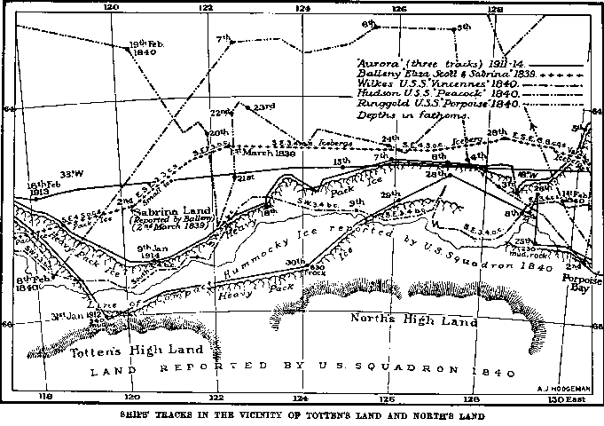
Ship's tracks in the vicinity
ot Totten's Land and North's Land
At 8 P.M. the sky was very clear to the
southward, and the land could be traced to a great distance
until it faded in the south-west. But the ship had come
up with the solid floe-ice once more, and had to give
way and steam along its edge. This floating breakwater held
us off and frustrated all attempts to reach the goal which
we sought.
``The next four days was a period of violent
gales and heavy seas which drove the ship some distance
to the north. Nothing was visible through swirling clouds
of snow. The `Aurora' behaved admirably, as she invariably
does in heavy weather. The main pack was encountered on
January 29, but foggy weather prevailed. It was not until
noon on January 31 that the atmosphere was sufficiently
clear to obtain good observations. The ship was by this
time in the midst of heavy floe in the vicinity of longitude
119 degrees E., and again the course had swung round to
south. We had soon passed to the south of Balleny's
Sabrina Land without any indication of its existence. Considering
the doubtful character of the statements justifying its
appearance on the chart, it is not surprising that we did
not verify them.
``At 11 A.M. the floes were found
too heavy for further advance. The ship was made fast to
a big one and a large quantity of ice was taken on board
to replenish the fresh-water supply. A tank of two hundred
gallons' capacity, heated within by a steam coil from
the engineroom, stood on the poop deck. Into this ice was
continuously fed, flowing away as it melted into the main
tanks in the bottom of the ship.
``At noon the weather
was clear, but nothing could be discerned in the south except
a faint blue line on the horizon. It may have been a 'lead '
of water, an effect of mirage, or even land-ice--in any
case we could not approach it.''
The position
as indicated by the noon observations placed the ship within
seven miles of a portion of Totten's High Land in Wilkes's
charts. As high land would have been visible at a great
distance, it is clear that Totten's High Land either
does not exist or is situated a considerable distance from
its charted location. A sounding was made in three hundred
and forty fathoms.
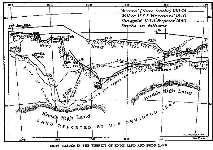
Ship's track in the vicinity of
Knox Land and Budd Land
Towards evening the `Aurora' turned
back to open water and cruised along the pack-ice. A sounding
next day showed nine hundred and twenty-seven fathoms.
It was about this time that a marked improvement was
noted in the compass. Ever since the first approach to Adelie
Land it had been found unreliable, for, on account of the
proximity to the magnetic pole, the directive force of the
needle was so slight that very large local variations were
experienced.
The longitude of Wilkes's Knox Land
was now approaching. With the exception of Adelie Land,
the account by Wilkes concerning Knox Land is more convincing
than any other of his statements relating to new Antarctic
land. If they had not already disembarked, we had hoped
to land the western party in that neighbourhood. It was,
therefore, most disappointing when impenetrable ice blocked
the way, before Wilkes's``farthest south'' in
that locality had been reached. Three determined efforts
were made to find a weak spot, but each time the
`Aurora'
was forced to retreat, and the third time was extricated
only with great difficulty. In latitude 65 degrees 5'
S. longitude 107 degrees 20' E., a sounding of three
hundred fathoms was made on a rocky bottom. This sounding
pointed to the probability of land within sixty miles.
Repulsed from his attack on the pack, Captain Davis
set out westward towards the charted position of Termination
Land, and in following the trend of the ice was forced a
long way to the north.
At 7.40 A.M., February 8,
in foggy weather, the ice-cliff of floating shelf-ice was
met. This was disposed so as to point in a north-westerly
direction and it was late in the day before the ship doubled
its northern end. Here the sounding wire ran out for eight
hundred and fifty fathoms without reaching bottom. Following
the wall towards the south-south-east, it was interesting
at 5.30 P.M. to find a sounding of one hundred and ten fathoms
in latitude 64 degrees 45'. A line of large grounded
bergs and massive floe-ice was observed ahead
trailing
away from the ice-wall towards the north-west.
On
plotting the observations, it became apparent that the shelf-ice
was in the form of a prolonged tongue some seven miles in
breadth. As it occupied the position of the ``Termination
Land'' which has appeared on some charts, (after
WiIkes) it was named Termination Ice-Tongue.
A blizzard
sprang up, and, after it had been safely weathered in the
lee of some grounded bergs, the `Aurora' moved off on
the afternoon of February 11. The horizon was obscured by
mist, as she pursued a tortuous track amongst bergs and
scattered lumps of heavy floe. Gradually the sea became
more open, and by noon on February 12 the water had deepened
to two hundred and thirty-five fathoms. Good progress was
made to the south; the vessel dodging icebergs and detached
floes.
The discovery of a comparatively open sea
southward of the main pack was a matter of some moment.
As later voyages and the observations of the Western Party
showed, this tract of sea is a permanent feature of the
neighbourhood. I have called it the Davis Sea, after the
captain of the `Aurora', in appreciation of the fact
that he placed it on the chart.
At noon, on February
13, in latitude 65 degrees 54 1/2' S. longitude 94 degrees
25' E., the western face of a long, floating ice-tongue
loomed into view. There were five hundred fathoms of water
off its extremity, and the cliffs rose vertically to one
hundred feet. Soon afterwards land was clearly defined low
in the south extending to east and west. This was thenceforth
known as Queen Mary Land.
The sphere of operations
of the German expedition of 1902 was near at hand, for its
vessel, the `Gauss', had wintered, frozen in the pack,
one hundred and twenty-five miles to the west. It appeared
probable that Queen Mary Land would be found to be continuous**
with Kaiser Wilhelm II Land, which the Germans had reached
by a sledging journey from their ship across the intervening
sea-ice.
** Such was eventually proved to be the
case.
The `Aurora' followed the western side
of the ice-tongue for about twenty miles in a southerly
direction, at which point there was a white expanse of floe
extending right up to the land. Wild and Kennedy, walking
several miles towards the land, estimated that it was about
twenty-five miles distant. As the surface over which they
travelled was traversed by cracks and liable to drift away
to sea, all projects of landing there had to be abandoned;
furthermore, it was discovered that the ice-tongue, alongside
of which the ship lay, was a huge iceberg. A landing on
it had been contemplated, but was now out of question.
The main difficulty which arose at this juncture was
the failing coal-supply. It was high time to return to Hobart,
and, if a western base was to be formed at all, Wild's
party would have to be landed without further delay. After
a consultation, Davis and Wild decided that under the circumstances
an attempt should be made to gain a footing on the adjacent
shelf-ice, if nothing better presented itself.
The
night was passed anchored to the floe, on the edge of which
were numerous Emperor penguins and Weddell seals. A fresh
south-easterly wind blew on February 14, and the ship was
kept in the shelter of the iceberg. During the day enormous
pieces were observed to be continually breaking away from
the berg and drifting to leeward.
Captain Davis continues:
``At midnight there was a strong swell from the north-east
and the temperature went down to 18 degrees F. At 4 A.M.,
February 15, we reached the northern end of the berg and
stood first of all to the east, and then later to the south-east.
``At 8.45 A.M., shelf-ice was observed from aloft, trending
approximately north and south in a long wall. At noon we
came up with the floe-ice again, in about the same latitude
as on the western side of the long iceberg. Land could be
seen to the southward. At 1 P.M. the ship stopped at the
junction of the floe and the shelf-ice.''
Wild, Harrison and Hoadley went to examine the shelf-ice
with a view to its suitability for a wintering station.
The cliff was eighty to one hundred feet in height, so that
the ice in total thickness must have attained at least as
much as six hundred feet. Assisted by snow-ramps slanting
down on to the floe, the ascent with ice-axes and alpine
rope was fairly easy.
Two hundred yards from the
brink, the shelf-ice was thrown into pressure-undulations
and fissured by crevasses, but beyond that was apparently
sound and unbroken. About seventeen miles to the south
the rising slopes of ice-mantled land were visible, fading
away to the far east and west.
The ice-shelf was
proved later on to extend for two hundred miles from east
to west, ostensibly fusing with the Termination Ice-Tongue,
whose extremity is one hundred and eighty miles to the north.
The whole has been called the Shackleton Ice-Shelf.
Wild and his party unanimously agreed to seize upon
this last opportunity, and to winter on the floating ice.
The work of discharging stores was at once commenced.
To raise the packages from the floe to the top of the ice-shelf,
a ``flying-fox`` was rigged.
``A kedge-anchor was
buried in the sea-ice, and from this a two-and- a-half-inch
wire-hawser was led upwards over a pair of sheer-legs on
top of the cliff to another anchor buried some distance
back. The
whole was set taut by a tackle. The stores
were then slung to a travelling pulley on the wire, and
hauled on to the glacier by means of a rope led through
a second pulley on the sheer-legs. The ship's company
broke stores out of the hold and sledged them three hundred
yards to the foot of an aerial, where they were hooked on
to the travelling-block by which the shore party, under
Wild, raised them to their destination.''
``It was most important to accelerate the landing as
much as possible, not only on account of the lateness of
the season--the `Gauss' had been frozen in on February
22 at a spot only one hundred and seventy miles away--but
because the floe was gradually breaking up and floating
away. When the last load was hoisted, the water was lapping
within ten yards of the ``flying-fox''.
A fresh west-north-west wind on February
17 caused some trouble. Captain Davis writes:
``February
19. The floe to which we have been attached is covered by
a foot of water. The ship has been bumping a good deal to-day.
Notwithstanding the keen wind and driving snow, every one
has worked well. Twelve tons of coal were the last item
to go up the cliff.''
In all, thirty-six
tons of stores were raised on to the shelf-ice, one hundred
feet above sea-level, in four days.
``February 20.
The weather is very fine and quite a contrast to yesterday.
We did not get the coal ashore a moment too soon, as this
morning the ice marked by our sledge tracks went to sea
in a north-westerly direction, and this afternoon it is
drifting back as if under the influence of a tide or current.
We sail at 7 A.M.
to-morrow.
``I went on to the
glacier with Wild during the afternoon. It is somewhat crevassed
for about two hundred yards inland, and then a flat surface
stretches away as far as the eye can see. I wished the party
`God-speed' this evening, as we sail early to-morrow.''
Early on February 21, the ship's company gave their
hearty farewell cheers, and the `Aurora' sailed north,
leaving Wild and his seven companions on the floating ice.
The bright weather of the immediate coastal region was
soon exchanged for the foggy gloom of the pack.
``February
21, 11 P.M. We are now passing a line of grounded bergs
and some heavy floe-ice. Fortunately it is calm, but in
the darkness it is difficult to see an opening. The weather
is getting thick, and I expect we shall have trouble in
working through this line of bergs.
``February 22.
I cannot explain how we managed to clear some of the bergs
between 11 P.M. last night and 3 A.M. this morning. At first
stopping and lying-to was tried, but it was soon evident
that the big
bergs were moving and would soon hem us
in: probably in a position from which we should be unable
to extricate ourselves this season.
``So we pushed
this way and that, endeavouring to retain freedom at any
cost. For instance, about midnight I was `starboarding'
to clear what appeared to be the loom of a berg on the starboard
bow, when, suddenly, out of the haze a wall seemed to stretch
across our course. There was no room to turn, so `full speed
astern' was the only alternative. The engines responded
immediately, or we must have crashed right into a huge berg.
Until daylight it was ice ahead, to port and to starboard--ice
everywhere all the time. The absence of wind saved us from
disaster. It was a great relief when day broke, showing
clearer water to the northward.''
On February
23, the `Aurora' left the shelter of Termination Ice-Tongue,
and a course was set nearly true north. There was a fresh
breeze from the north-east and a high sea. The ship was
desperately short of ballast and the coal had to be carefully
husbanded. All movable gear was placed in the bottom of
the ship, while the ashes were saved, wetted and put below.
The ballast-tanks were found to be leaking and Gillies had
considerable trouble in making them watertight.
The
distance from the Western Base in Queen Mary Land to Hobart
was two thousand three hundred miles, through the turbulent
seas of the fifties and forties. It was the end of a perilous
voyage when the `Aurora' arrived in Hobart with nine
tons of coal.
On March 12, the captain's log
records:
``The `Aurora' has done splendidly,
beating all attempts of the weather to turn her over. We
had two heavy gales during the first week of March, but
reached Hobart safely to-day, passing on our way up the
Derwent the famous Polar ship, `Fram', at anchor in
Sandy Bay. Flags were dipped and a hearty cheer given for
Captain Amundsen and his gallant comrades who had raised
the siege of the South Pole.''
CHAPTER V -FIRST DAYS IN ADELIE LAND