Climate Change - Science in Antarctica
Antarctica is important to the climate of the whole planet, it acts as a barometer of change. Antarctic weather and climate systems once thought to be largely isolated are now known to feed into the systems of the rest of the world and can act as a buffer to changes or continue climate changes long after the triggers have been stabilized.
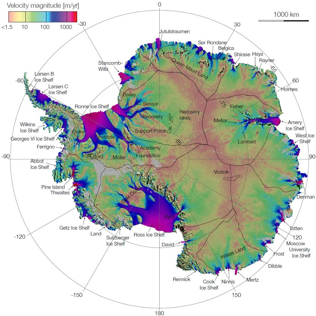
Ice flow rate map of Antarctica showing how ice from the great sheet covering the continent reaches the sea at relatively few points around the coast via very active glaciers and ice shelves. The map is the result of twenty years of data from satellites.
Antarctica is the scene of much investigation into climate change for a number of reasons:
- Antarctic ice cover is a regulator of energy
absorbed from the sun, ice reflects back the sun's
energy causing less warming, changes may have far reaching
effects.
- Antarctic glaciers and ice shelves contain huge
amounts of water that could potentially raise sea levels
around the world if they collapse or melt. The
size and rate of ice berg formation and position of the
edge of ice shelves are monitored to understand the bigger
picture.
- Each winter sea ice forms around Antarctica
approximately doubling the area of the continent,
the extent and thickness of this ice gives an indication
of short and long-term temperature and climate changes of
the sea and atmosphere.
- Antarctic ice contains a climate record going
back a million years. As it forms, ice contains
trapped bubbles of air from that time allowing us to sample
the atmosphere at known times in the past so allowing us
to learn about ancient climates in detail.
- The ozone hole over Antarctica is now known
to have climate effects that extend into other regions.
- Ocean currents transport warm and cold water
around the planet and Antarctica plays a crucial
role in these circulations, understanding these circulations
allow us to predict changes.
- Because Antarctica is so isolated and relatively unaffected by the immediate presence of people, it is an ideal place to carry out experiments and observations, it also reacts in ways that make it a good barometer of changes that are less easy to decipher elsewhere.
Society and its leaders need the best evidence and understanding of the mechanisms and effects of climate change, both current and for future forecasts. We need to be able to separate changes that are naturally occurring from those that are the result of or exacerbated by human activities. In either case building a sophisticated predictive model is of the utmost importance and this requires reliable and accurate observation and measurement of Antarctic climate past and present.
Here are some climate science research projects taking
place now or recently in Antarctica.
Antarctic Ice Cover - Sea-ice - Glaciers and Ice-sheets
Observations and measurement of the ice covering Antarctica, the way that glaciers flow, the formation of ice shelves and ice bergs and the seasonal changes in sea-ice are of the utmost importance to climate scientists, in particular tracking the ways that these things change over time is vital to understanding climate changes.
Ice Bridge
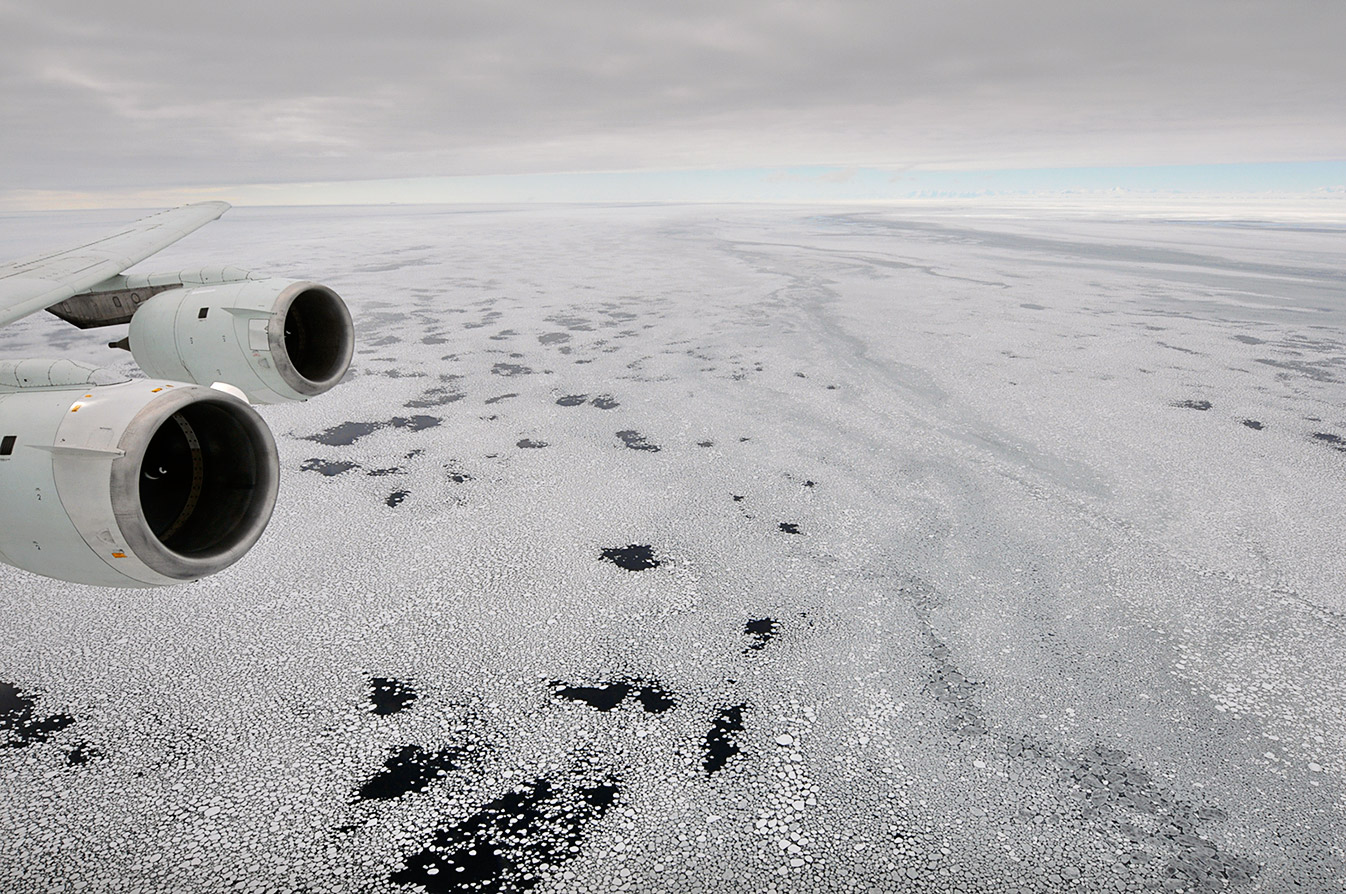
Antarctic Sea Ice
Sea ice seen out the window of
a NASA DC-8 research aircraft at 2,000 feet above the Bellingshausen
Sea, West Antarctica, 2009. Photo Credit: NASA/Jane Peterson
Antarctica is however a very big and distant place, covering 14 million square kilometers with another 18 million square kilometers of sea-ice that forms and mostly melts again every year. Combined with its remoteness, this presents significant practical difficulties in measuring and monitoring the ice.
In recent years a combination of satellites and aircraft flying patterns across the whole of the continent have allowed observations, measurements and visualizations of the ice cover and how it changes to be determined in unprecedented detail. Instruments can continually measure parameters such as snow depth, ice elevation, ice thickness, surface temperature, bed rock topography and a range of other characteristics of sea ice, ice sheets and glaciers as the satellite or aircraft flies over.
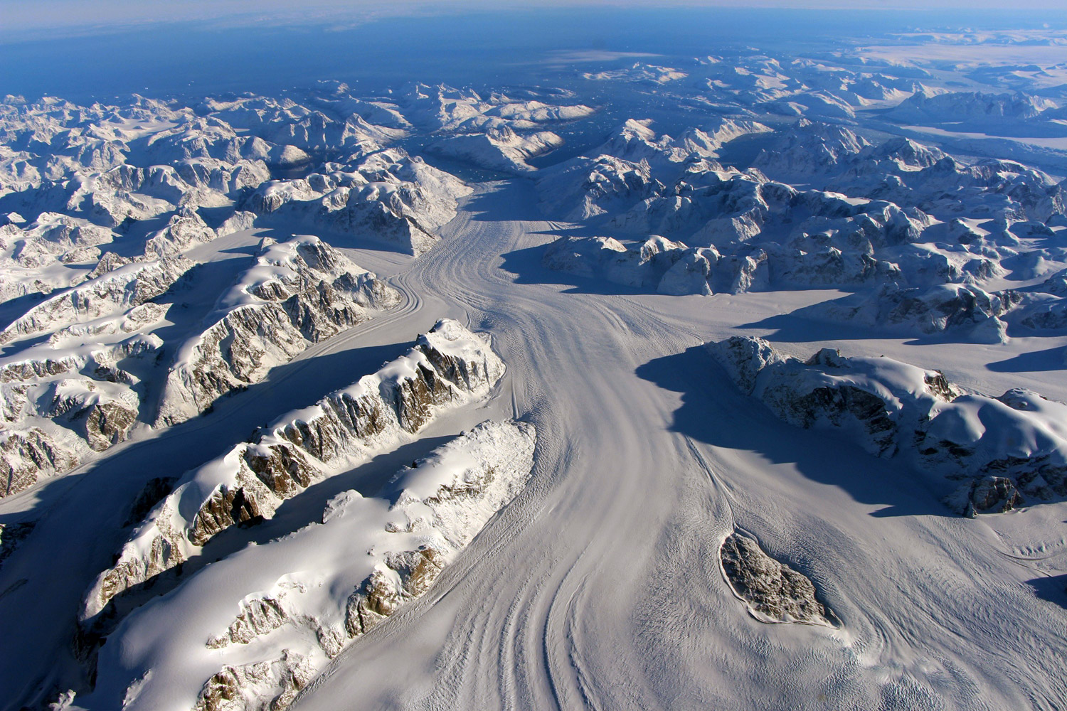
Ice Bridge,
Greenland, Heimdal glacier
Photo Credit: NASA/Goddard
Ice cover
Antarctica is amostly ice covered area that reflects the light and heat of the sun to play a large part in the regulation of climate in the region and globally.
This ice cover has grown and shrunk repeatedly over geological time with eight cycles of an ice age followed by a warm period in the last 800,00 years, this growth and shrinkage of the ice cover has resulted in a rise and fall in global sea levels. Evidence from ice cores and marine sediments have allowed us to discover these changes in some detail along with other factors such as temperature and carbon dioxide levels in the atmosphere. This enables us to get a better picture of what stage in the cycle we are in currently and what may happen in the future.
Ice in glaciers and ice shelves
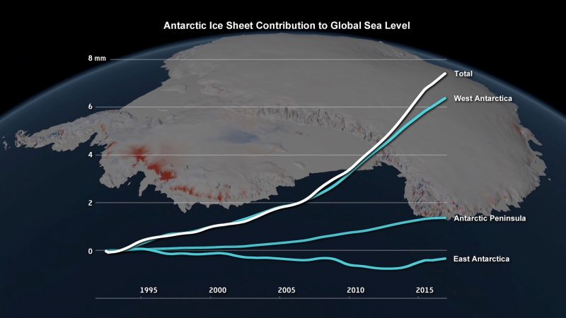
Most of the ice in Antarctica is frozen fresh-water ice that has fallen as snow or formed as rime, it is held on the land and above sea-level. It is slowly sliding down to the oceans surrounding the continent where it falls off the end and adds extra water to the sea causing it to rise. In a stable system, ice that falls off around the edge is balanced by snow fall in the interior, so the level of the sea remains stable. Currently the ice sheet in Western Antarctica at least is losing ice an an accelerated rate. ref
If the ice in the Western Antarctic Ice Sheet, WAIS were to melt, it would add about 3.2m to global sea levels, the Antarctic Peninsula ice sheet alone would add 0.24m while if the whole of the Eastern Antarctic Ice Sheet were to melt, it would add 60m to global sea level, in all there is about 26.5 million cubic kilometres of ice frozen in Antarctica. ref
This ice is not however a simple layer over the land that is uniformly slipping sea-wards. The presence of largely buried mountain ranges under the ice, a surface bed-rock layer that is far from smooth and may be as much as 2,555m (8,382 ft) below sea-level at the Bentley sub-glacial trench make the situation much more complex.
Mountains, floating ice shelves, ridges and bumps where glaciers can snag whether on land or once they are floating mean that the ice flowing to the coast gets channeled at certain points and some glaciers where they meet the sea act like a leaky cork in a tipped up bottle. The ice still flows though much more slowly than it would if the cork were removed. A current concern is whether or not one or more of these glacier "corks" may slip out so releasing the ice behind them at a much faster rate.
Runaway Glaciers in West Antarctica, video 2 mins 14 secs
Winter Sea Ice
Sea ice in Antarctica forms each year as the autumn arrives in March and April and starts to break up and melt during October and November, about 18 million square kilometers of ice form during this time which more than doubles the continental area, this is the biggest seasonal change on earth. Most of the ice is one-year ice which forms and melts again as the edge of the Antarctic Ocean is unconstrained by land unlike in the Arctic where multi year ice is more common.
Like the continental ice, sea ice reflects sunlight, it also forms a barrier between the sea and the air so affecting how heat and gases (principally carbon dioxide) are exchanged. Sea ice formation and melting also affect the saltiness of the surface waters affecting density and melting point which in turn affects the mixing of surface and deeper waters which can have effects on climate at a local and global level.
Sea ice is particularly difficult to understand as it is influenced by many different factors. Counter-intuitively the more heat in the system around Antarctica can result in more sea ice forming in a particular winter. In recent years both winter maximum and summer minimum records of sea-ice have been broken since the first satellite measurements began to be taken in 1979. newspaper article | article in Nature
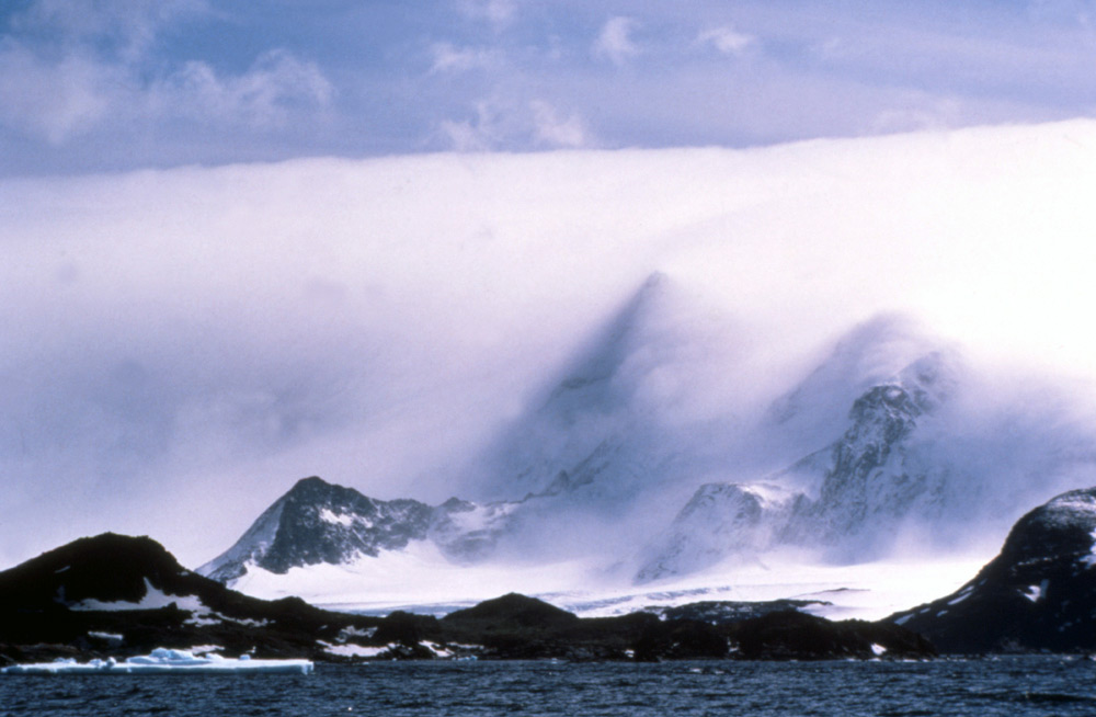
The Antarctic Peninsula
A long mountainous peninsula of land that reaches out from Antarctica towards South America and the site of the most dramatic climate changes. Human induced climate change led to strong westerly winds in the northern region of the peninsula which in turn led to regional warming in the summer months and the retreat and collapse of the Larsen ice shelf. ref | scientific paper
Picture right - a Foehn wind causing a blanket of cloud known as a Foehn bank, the kind that caused melting that led to the collapse of the Larsen C ice shelf.
Antarctic Ice Core Climate Record
An ice core is a cylinder of ice that is drilled out of an ice cap using a tubular drill bit typically 10-20cm in diameter and from 1-6m long. The drill is lowered on a steel cable and is powered by an electric motor on top of the drill bit, fed by power from an electrical cable from the surface. Once the bit is full of an ice core, it is brought back to the surface and the ice is carefully removed, labeled and stored. The drill is now lowered into the hole again to take the next ice core, going further back in time the deeper it gets.
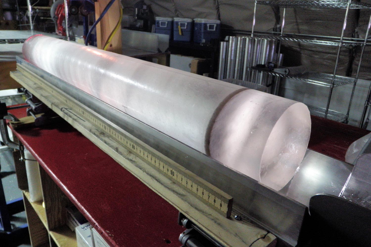
An ice core removed
from the drill.
The cores of ice can be aged and chemically and isotopically sampled to determine the temperature at the time of formation and the atmospheric gas concentrations at known points in the past. By this means we can determine when past ice ages started and ended. Data for this has come from the Antarctic and Greenland ice sheets.
Unequivocal evidence has shown that since the start of the Industrial Revolution when fossil fuels began to be burnt in great quantity, the amount of greenhouse gases entering the atmosphere has increased beyond that caused by natural events. The current amount of atmospheric carbon dioxide at over 400 parts per million and steadily rising (see here for daily figures) is greater than any value measured in ice cores covering the last 800,000 years. The figure of 800,000 is the longest we can currently go back and measure carbon dioxide levels with any degree of accuracy.
See here for more detail on drilling ice cores.

Ice cores are transported
very carefully from Antarctica and stored in giant freezers.
Climate Effects of the Ozone Hole Over Antarctica
The ozone "hole" over Antarctica is a thinning of the layer of naturally occurring ozone gas found at high altitudes that filter out some of the ultra violet radiation coming from the sun. This varies in size over the year growing during the winter months peaking in September and then recovering somewhat during the summer. In 1985 the size of the ozone hole was discovered to be far bigger and more severe than previously thought. Ozone depletion is caused by industrial chemicals called chlorofluorocarbons (CFC's), international agreement on their reduction was agreed in 1987, the so-called "Montreal Protocol".
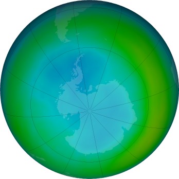
July
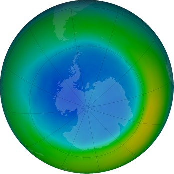
August
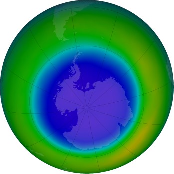
September
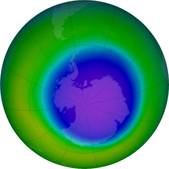
October
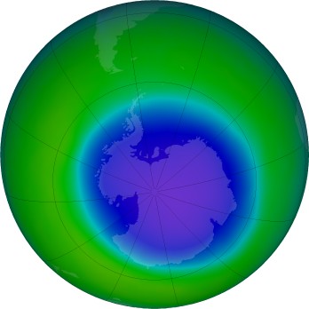
November
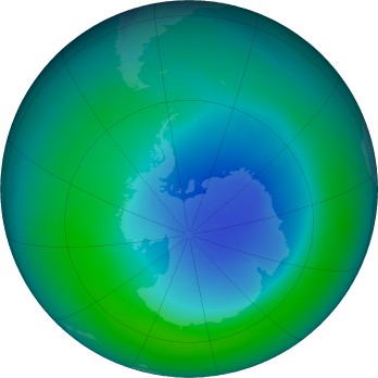
December
Aside from the problems of the ozone hole caused by extra ultra violet light getting through it is now known that the ozone hole has a profound effect on the climate of Antarctica. Ozone is found high up in the stratosphere, a thinning over Antarctica caused a fall in the temperature in this layer leading to an increased difference in temperature compared to the tropics leading to effects on the Southern Hemisphere weather patterns. Since 1980 the strength of winds in the Southern Ocean have increased by 15% as a result so acting against the warming effects of greenhouse gases to some extent bringing warmth inwards from more northern regions and allowing more heat to pass out t space.
The ozone hole and global warming combined have caused westerly winds blowing relatively warm air across the Antarctic Peninsula towards the east up and over the 2000m mountain range. In the summer, this can cause a 5°C temperature rise which led to the collapse of the Larsen Ice Shelf in 2002. ref
Ocean Currents Around the Planet
The surface ocean waters around Antarctica become very cold and salty as salt is expelled from sea ice as it forms and ages. This water becomes dense and sinks, it is known as Antarctic Bottom Water and is formed mainly in the Ross and Weddell Seas. It is the densest of of sea water masses in the world, sinking deep and flowing northwards becoming an important component of a planet-wide circulatory system called the "great ocean conveyor". This is very important in that it redistributes heat around the planet as cold and warm water masses are moved around.
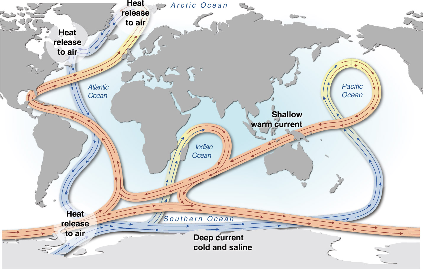
The major ocean currents
driven by the thermohaline circulation, a combination of temperature
and salinity differences affecting the density of sea water.
This dense mass of water also takes much of the extra carbon dioxide gas from the atmosphere with it that has been generated since the industrial revolution. Gases dissolve better in water that is cold and the waves and mixing in the Southern Ocean caused by strong circumpolar westerly winds mean that it is a particularly good "sink" for the extra greenhouse gas, though it is becoming more acidic in the process which poses problems for living things that make shells. The Southern Ocean currently absorbs over 40% of human produced carbon dioxide.

Under sea-ice in the
Ross Sea, the large structures above the diver are "brinicles"
or underwater icicles, actually hollow tubes of ice formed when
colder highly saline water is expelled by the sea-ice above
and falls due to higher density, its lower temperature causes
the water around it to freeze forming the brinicle, part of
the mechanism of the formation of Antarctic Bottom Water. Photo:
Rob Robbins NSF
Much research work is going into the global reach of the Antarctic atmosphere and Southern Ocean to find out about the underlying processes and interactions between them, in particular the influence on the populated regions of the world
Experiments and observations in an Isolated Region
Being so far removed from major population centres and difficult to get to, Antarctica is the largest place on earth that is not directly influenced by human activities. This makes it a good place to carry out studies and observations that elsewhere may be confused by other factors. The fact that it is largely frozen, though temperatures may sometimes rise above freezing temporarily also make it a good place to see the wider affects of relatively small increases in average temperatures.
For instance if the average temperature of a place is below freezing and fluctuations still don't take the temperature above freezing, everything remains solid and icy. A small increase in average temperature may result in the average still being below freezing, but fluctuations above freezing, so that snow man you made ten years ago and is still there suddenly melts one afternoon, even though it gets cold again in the evening - for example.
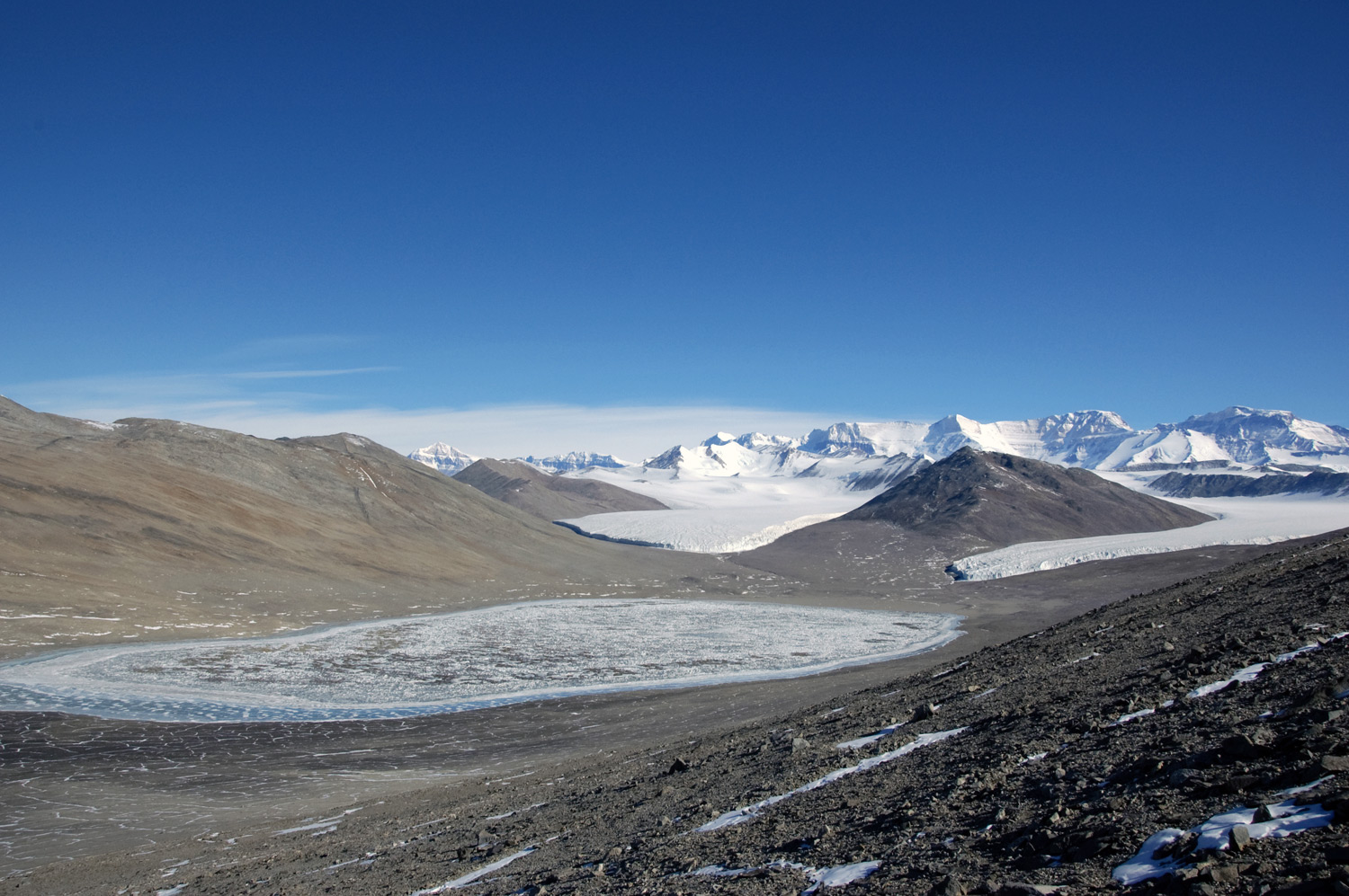
There is evidence from across the world that intense weather events are becoming more frequent and this extends to Antarctica as measured in the Dry Valleys. The temperature doesn't doesn't even need to get above freezing point for melting to occur on a particularly sunny day. Changes in the Dry Valleys involving more melting and thawing are starting to change the biological communities already from what was a steady state for as long as they have been measured until just after 2000. While changes to a very impoverished ecosystem in Antarctica may seem of little consequence, such studies show in isolation what kinds of changes can occur with what appear to be relatively small shifts in temperature and help to give insights into how other parts of the world may react. In other regions, the shifts in populations may affect pest species.
Long term data collection projects related to climate change:
- Weather data from surface and upper air measurements
for forecasting and showing climatic trends.
- Observations of annual changes in upper atmosphere ozone
concentrations.
- Samples of air and snow to monitor changes in greenhouse
gases in the atmosphere and in the ice.
- Ground measurements of the occurrence of global lightning,
and wave activity in the magnetosphere.
- Ground measurements of the temperature of the mesosphere
(87km above the Earth's surface).
- Monitoring of selected marine species various locations.
- Measurements of changes in ocean currents, nutrients
and temperature.
- Sea-ice observations to identify annual and ten-year
trends.
- Surveying the diversity of groups of organisms on land
and at sea and how they change over time.
- Surveys of ice and surface features such as glaciers
and ice streams.
- Aerial photography and ground-based topographic surveys.
Picture references: Ocean currents - Hugo Ahlenius, UNEP/GRID-Arendal | Top banner - Thwaites glacier 2012, James-Yungel NASA